


PH Weather And Earthquakes
Description of PH Weather And Earthquakes
PH Weather And Earthquakes is a mobile application that provides users with real-time weather updates and seismic activity information in the Philippines. This app is designed for the Android platform, and users can download PH Weather And Earthquakes to stay informed about various environmental conditions. Formerly known as PHIVOLCS Earthquake Alerts, the app has expanded its functionality to include comprehensive weather data sourced from PAGASA, the Philippine Atmospheric Geophysical and Astronomical Services Administration.
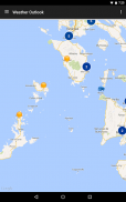
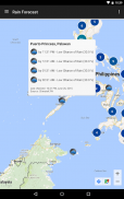
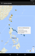
The app features weather updates that encompass a four-hour forecast, a four-day forecast, and cyclone alerts, allowing users to plan their activities accordingly. These updates are vital for residents of the Philippines, where weather conditions can change rapidly. Users can access information on typhoons, hurricanes, and other types of cyclones, which is crucial for safety and preparedness.
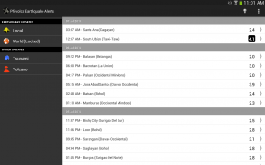
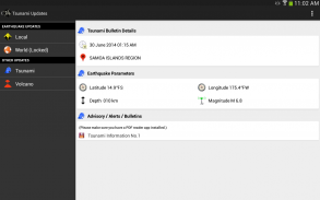
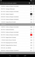
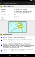
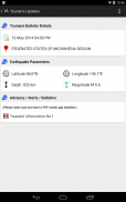
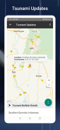
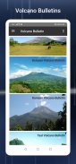
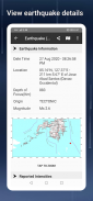
In addition to weather information, PH Weather And Earthquakes offers alerts related to earthquakes, tsunamis, and volcanic activities. This aspect of the app is powered by data from PHIVOLCS, the Philippine Institute of Volcanology and Seismology. Users can receive timely notifications about seismic events, making it an essential tool for those living in earthquake-prone regions.
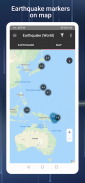
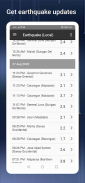
A notable feature of the app is its worldwide earthquake list, which compiles data from the U.S. Geological Survey (U.S.G.S). This allows users to monitor seismic activity not just locally but also globally, providing a broader perspective on tectonic events.
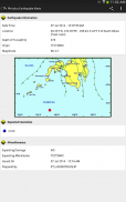
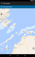
The app includes a visual map section that highlights the Valley Fault System, aiding users in understanding the geophysical landscape of the Philippines. The map feature allows individuals to identify fault lines and their proximity to residential areas, which is particularly important for risk assessment and mitigation strategies. Users can also access downloadable resources from PHIVOLCS, enhancing their understanding of geological hazards.
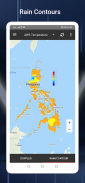
PH Weather And Earthquakes incorporates monitoring tools such as Doppler radar, stream gauges, rain gauges, tide levels, and weather stations. These tools provide users with precise and localized weather data, enabling them to make informed decisions based on current conditions. The integration of these technologies helps users stay aware of potential hazards such as floods and landslides, which are common in various regions of the Philippines.
Hazard maps are another significant feature of the app, showcasing areas at risk for floods, landslides, and storm surges. This information is crucial for disaster preparedness, allowing users to identify safe zones and evacuation routes in case of emergencies.
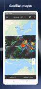
The application also features MT satellite images and videos, which provide visual insights into weather patterns and environmental changes. These multimedia resources enhance user understanding of the current climate and potential weather-related events.
For health and safety, the app includes Ovitrap reports, which monitor dengue fever risks. By providing information about mosquito breeding sites, users can take preventive measures to protect themselves and their families from dengue outbreaks.
Users can also benefit from a boundaries map that delineates provincial, municipal, and barangay levels. This feature is useful for understanding local governance and community resources, including critical facilities such as schools, hospitals, police stations, and fire stations nationwide.
Emergency tools integrated within the app, such as a flashlight, strobe light, siren, and compass, assist users in navigating challenging situations. These tools can be vital during power outages or natural disasters, providing users with essential resources at their fingertips.
The app also offers Twitter updates from government agencies, including PAGASA, PHIVOLCS, MMDA, DPWH, NDRRMC, and the Red Cross. This feature ensures that users have access to the latest information from official sources, further enhancing the app's reliability.
Weekly and hourly weather forecasts based on custom searches for specific cities allow users to receive tailored information relevant to their locations. This customization helps users stay informed about changing weather conditions in their immediate environment.
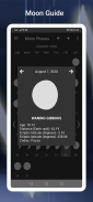
Lastly, the app includes a moon phase calendar that displays lunar phases along with zodiac signs. This feature adds a cultural aspect to the app, appealing to users interested in astronomy and astrology.
PH Weather And Earthquakes serves as a multifaceted tool that combines weather monitoring, seismic alerts, and emergency preparedness resources. By providing comprehensive information and features, it aims to keep users informed and safe in the face of natural events. The app effectively integrates various functionalities, making it a valuable resource for individuals living in the Philippines and those interested in monitoring environmental conditions.
PH Weather And Earthquakes - Version 4.13
(03-12-2024)PH Weather And Earthquakes - APK Information
APK Version: 4.13Package: org.droidgox.phivolcsLatest Version of PH Weather And Earthquakes
Other versions


Apps in the same category


